IIHR’s Water-quality Network Grows
July 29, 2016
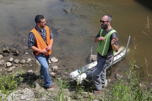
IIHR’s Tom Stoeffler (right) talks with Dan Mahoney, watershed coordinator of the West Fork Crooked Creek Demonstration Project. The new water-quality sensor can be seen behind them.
“What’s in the water?”
Until recently, the answer to that question was usually, “We just don’t know.” Now, thanks to a network of water-quality sensors deployed and maintained by IIHR—Hydroscience & Engineering, water-quality data is readily available for many sites in Iowa.
The network of sensors, which measure nitrate and other water-quality variables, continues to grow. Most recently, IIHR staff installed a new sensor on West Fork Crooked Creek south of Washington, Iowa.
Local watershed officials were on hand to watch the installation and check out the new sensor as it was deployed on July 27. Dan Mahoney, watershed coordinator of the West Fork Crooked Creek Demonstration Project, says the sensor will help the Washington County project team gauge progress as they work to reduce sediment and nitrate in the stream. “We can keep track on a daily basis now,” he says.
Kate Giannini, a Washington County soil commissioner, agrees that the sensor is a great new asset for the county. The partnership with the University of Iowa and IIHR is especially important, she says, because it allows them to continue monitoring progress and to understand the effects of various land management practices.
Kevin Reed, a farmer and local landowner, says he and his family have been early adaptors of sustainable farming practices such as no-till farming, cover crops, and more. When asked why, he says, “Because somebody needs to lead. My water is flowing through this stream.”
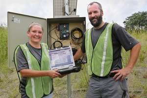
IIHR’s Carrie Davis and Tom Stoeffler installed the new sensor on West Fork Crooked Creek; it almost immediately popped up on the Iowa Water-Quality Information System (IWQIS).
Washington County farmers have been leading Iowa’s quest to improve water quality in the state. Mahoney says the West Fork Crooked Creek Demonstration Project is now in the third year of a three-year grant, and they’re hoping for three more years. In particular, the project encourages farmers to plant cover crops — small grains and grasses planted in the fall after corn or soybeans have been harvested to provide a protective living cover for the land. Cover crops protect the soil, reduce erosion, and contribute to improvements in water quality.
Mahoney says that cover crops are especially important in southeast Iowa, with its hilly, highly erodible ground. About 120 farmers in the 80,000-acre West Fork Crooked Creek Watershed are participating in the project by incorporating sustainable farming practices.
“Everybody’s pretty much on board in this area,” Reed says. “We’re all in it.”
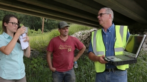
IIHR’s Chris Jones (right) shows onlookers the IWQIS site, where the new sensor was already reporting data.
IIHR Research Engineer Chris Jones reported the first sensor reading when it popped up on the Iowa Water-Quality Information System — 8.0 mg/L. That’s less than the EPA limit for drinking water, 10.0 mg/L. And while there’s still room for improvement, now people who care about water quality in Iowa have real data to help guide decision-making and track progress toward the goal of the Iowa Nutrient Reduction Strategy — a 45% reduction in nitrogen and phosphorus loads.
Access to this kind of data is essential, Reed says. “People want to know. They’re paying attention.”
Check out the Iowa Water-Quality Information System and real-time data from the new West Fork Crooked Creek sensor.