Water for Today — and Tomorrow
March 7, 2019

Mike Gannon (right) meets with North Liberty Water Manager Greg Metternich (left) and Assistant Water Superintendent Shannon Kopecky to discuss groundwater modeling of the Jordan aquifer beneath Linn and Johnson counties.
In 1997, North Liberty was a typical small Iowa town of about 3,000 people. More than two decades later, this booming community just north of Iowa City has a population of almost 20,000. Growth like this requires good information and planning. One example is the city’s water supply. How can a community manage water needs that increase at this rate?
North Liberty Water Manager Greg Metternich says that modeling and information provided by Mike Gannon and his team at the Iowa Geological Survey (IGS) have been a key part of his community’s ability to provide water for its citizens as well as for industry.
“I can’t say enough for Mike,” Metternich says. “His work has really paid off great dividends.”
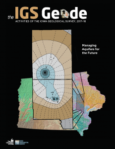
Gannon was part of a unique public-private partnership, working with local water users to quantify the long-term availability of water from the Jordan aquifer in Linn and Johnson counties. The IGS team developed and calibrated a three-dimensional local-scale groundwater flow model and used it to predict future water availability for industries and communities.
North Liberty pumps about 90 percent of its water from the Jordan aquifer. Gannon’s model simulated the groundwater flow around North Liberty’s wells, assessing current and future pumping rates and identifying any vulnerabilities.
Metternich says that the results have allowed North Liberty to pump more water from the Jordan aquifer. Prior to the modeling effort, the Iowa Department of Natural Resources had capped the city’s water production from the Jordan because of uncertainties in its sustainability. “The model has allowed the city to maximize water production while minimizing the impact on the aquifer,” Metternich explains. “It’s been a win-win for the city and the other area water users.”

This stylized groundwater model and bedrock map of Iowa were both developed by IGS to depict future water levels in the Jordan aquifer beneath Linn and Johnson counties.
The IGS model also helps water managers understand and address long-term, collective well interference, which occurs when many large public and industrial wells draw water from the same source. Individual wells can cause a decline in groundwater levels extending radially many miles from the well. “These depressions can interact with each other to accelerate and increase the overall drop in groundwater levels throughout the area,” Gannon explains. “Collective well interference makes prediction of long-term pumping water elevations virtually impossible based on observed water levels exclusively.” Fortunately, Gannon’s model can provide a comprehensive picture of the effects that area wells have in the aquifer.
Gannon’s model was able to simulate the effects of numerous wells drawing from the Jordan aquifer in Linn and Johnson counties. He found that additional future growth in water supplies is available for users in the two-county area. The IGS presented a conservative approach to the Iowa Department of Natural Resources that establishes a water use increase of no more than 30% for a five-year period. This approach allows communities and industries the ability to increase their water use, but also protects the aquifer for future generations. The model also provides a timetable to allow the city to look for additional water sources.
Metternich is grateful for the information provided by the IGS modeling project. He says he feels confident about the water source’s long-term viability “We should be sustainable for 20 years,” Metternich says. “This is very valuable information that will help for years to come.”


