For IMMEDIATE RELEASE: Thursday, October 1, 2026
Iowa City, Iowa, October 1, 2026 — The Iowa Flood Center (IFC) has launched an updated version of its flagship product, the Iowa Flood Information System (IFIS). The enhanced platform features improved visuals and a more intuitive design, advancing IFC’s mission to provide critical flood risk information to all Iowans. IFIS integrates multiple agencies’ flood and drought data visualizations, providing a comprehensive overview of the hydrologic conditions across Iowa.
The new software platform includes several enhancements that make flood information easier to access and understand. Users can explore real-time flood conditions, stream levels, and forecasts through a streamlined interface designed to help Iowans better assess flood risk and make informed decisions.
Updates to the new IFIS system include:
Integrated data and models from several agencies, such as the National Weather Service, the National Water Center, and the National Oceanic and Atmospheric Administration;
Flow forecasts and scenarios that help users understand how rising water levels upstream may impact downstream communities;
Flood frequency maps displaying the magnitude of 2- to 250-year flood events;
Rainfall data ranging from current observations to forecasted conditions;
Soil moisture and drought monitoring tools that provide insight into evolving conditions across the state;
Email and text alert sign-up for flood and other adverse weather condition notifications; and
Access to historical flood and water-level data.
IFIS continues to offer:
Up-to-the-minute stream-level information collected by more than 270 IFC-designed, -built, and -deployed stream sensors that share real-time data on IFIS. This statewide network complements U.S. Geological Survey stream gages by filling in data gaps on smaller streams to improve flood monitoring and forecasting;
Flood alerts and forecasts for more than 1,000 Iowa communities, helping Iowans better plan and prepare in advance of a flood;
Interactive flood maps that show the extent of possible flooding for every Iowa stream in all 99 counties;
Detailed, high-resolution flood inundation maps for dozens of Iowa cities and towns (with more added every year!) that show how predicted flood extent and depth could affect property and critical infrastructure; and
A network of 53 hydrologic weather stations, with more on the way, that collect data on rainfall, soil moisture and temperature conditions, shallow groundwater levels, and other weather data. IFC plans to add 20 new hydrostations to its network in southwest Iowa to improve flood and drought monitoring and forecasting.
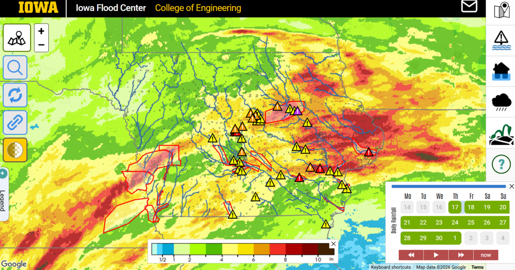
The redesigned IFIS homepage helps users quickly assess flood conditions across Iowa. Here, cumulative two-week rainfall totals are displayed alongside stream gages in action, minor, and moderate flood stages, with severe flood warning areas highlighted in red.
To explore the new IFIS platform, please visit: iowafloodcenter.uiowa.edu/ifis.
About the Iowa Flood Center:
The Iowa Flood Center is a part of IIHR—Hydroscience and Engineering at the University of Iowa College of Engineering. The IFC was created by the Iowa Legislature in 2009 in response to the devastating 2008 floods to improve flood monitoring and prevention in Iowa.
Contact:
Breanna Shea
Program Manager, Iowa Flood Center
Phone: 319-325-8674
Email: breanna-shea@uiowa.edu